Yahi Mapping Pilot |
Yahi Overview Relationship between Yahi and PSI Mapping Pilot Assembly Instructions Installation Instructions Developers Data FAQ |
Please note: the information below is out of date, I’m not adding more participants at the present time. - Roland 2015-05-11
Open Invitation to Participate
The Yahi project has reached the point where I’m ready to roll out 50-60 sensors across Singapore. If you’d like to participate then I’d love to hear from you. Please take 15 minutes to understand the objectives, requirements and risks and - if you’re happy with all of that - drop me an email as described under Applying to Participate in the Pilot.
If you’ve not already done so, you may wish to consider joining:
- the yahi-announce mailing list, which I use periodically to update interested people on the project’s status
- and possibly the yahi-discuss mailing list, which is open for discussion by anyone interested in the project.
Background
Objectives
The primary objective of this phase of the project is to get a network of sensors deployed and delivering data, and to produce a visualisation of that.
The secondary objective is to have that network of sensors in place before a particularly hazy period begins as this avoids a mad scramble once the haze is here (during which people may well have other priorities).
Requirements
To host a sensing station, you’ll need:
Financial
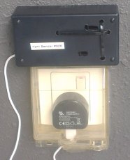
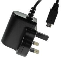
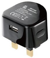
- To be willing to purchase the sensing station as an assembled kit from 12Geeks ($95), plus an inexpensive USB plug pack ($9) if you don’t have a spare one lying around (or a smaller-but-more-expensive USB plug pack ($20) if you’re performing the type of installation shown in the photo below).


Geographic and Infrastructural
- To be in Singapore.
- To have a partially sheltered outdoor place to install the device. A typical apartment balcony with a roof over it would be ideal.
- To have access to power at the installation location. I would strongly suggest that you only do this with a professionally-installed hooded power outlet. Running extension leads outside and leaving them for months is an invitation for trouble and I don’t yet have a solar-powered option available.
- To have access to WiFi at the installation location. This is a little more complicated, the Spark Core only operates on 2.4GHz and even then is known to have problems with less common network configurations:
There are many reasons that your Spark Core might not be able to connect to your network. There are many types of Wi-Fi networks, and the Spark Core and the CC3000 do not support all of them. We consider it an important goal of ours to connect easily and painlessly to as many networks as possible, and your feedback is extremely valuable so that we can get better.
The Spark Core works best with a traditional home network: simple networks with WPA/WPA2 or WEP security (or unsecured), with a single router from a reputable company (Apple, Netgear, Linksys, D-Link, etc.) without any fancy settings. The more your network diverges from the norm, there more likely you might encounter issues.
There are known issues with the following types of networks:
- 802.11n-only networks. The Spark Core is 802.11b/g. Most 802.11n networks are backwards compatible with 802.11b/g, but if yours is not, the Spark Core will not connect.
- Networks with "captive portal" security. A captive portal is the little website that comes up to ask you to sign in to a network or sign an agreement, like at a Starbucks. The Spark Core can't navigate these portals.
- Enterprise networks. We have had mixed results connecting the Spark Core to enterprise networks, although we don't yet have a great understanding of what's causing the issue. This is something that we are working to improve.
- Complex networks. Networks with multiple routers, with non-standard firewalls, and with non-standard settings.
- Channels above 11. This is in particular an international issue; if you are outside the U.S., your Wi-Fi router might run at channels 12, 13, or 14, which the CC3000 does not support. Please use channels numbered 11 or lower.
Desirable
It is also desirable, but not essential, that you have some experience in solving configuration issues with IT gear. The WiFi configuration step has been packaged to make it incredibly simple, but like most such things this means that if anything does go wrong then you’ll be doing a lot of head-scratching.
As you’re purchasing the device I can’t very well tell you what to do with it, but I would ask that you consider operating it as part of the mapping pilot for at least 90 days after purchase. With luck this project will run for a great deal longer (years) and I hope that most participants will keep their sensors operating indefinitely.
Risks
Risks in this experiment include:
Maths and Physics
The biggest risk is that it may turn out that a workable mathematical model can’t be constructed to usefully map sensor readings to PSI (or more specifically to PM2.5), or equivalently that more than a hour’s readings have to be averaged in order to do so, meaning that the sensor network does not end up adding useful information to what the NEA already publishes. This problem arises in large part because of the method of measurement used in Yahi sensors (more information). Part of the chicken and egg problem that we’re facing is that waiting until we have enough data to produce the model before deploying the sensors means that we risk missing much of the data that we’ll need to produce that model with in the first place. That is why I am still describing this as very much an experimental project at present.
Technology
You are unable to install the sensing station at your location, whether because your balcony isn’t laid out as expected, because there’s a problem with connecting to your WiFi network or perhaps because it becomes clear that your cat is likely to destroy it. In this case, and assuming that your cat has not already damaged it, simply advise 12Geeks promptly that you’d like to return it and work through their returns process.
I Give Up
At present this is a personal project run entirely by me. It is conceivable - if somewhat unlikely - that I’ll abandon the project. In this case, you own the device and are free to do with it as you wish. All of my software for this project is or will be on GitHub meaning that others can pick it up and run with it if they wish. An important detail is that as-shipped the Spark Cores will have been “claimed” by my spark.io account in order to load the firmware; I undertake to release your Core upon request at any time, whether I’ve abandoned the project or not. As above, I’d hope that, in any event, you’d allow the device to gather and contribute data for at least 90 days before doing so.
I Turn Pro
I turn this into a business and fail to adequately recognise the contribution of my early volunteers. This is a tricky one but
- (a) I really don’t intend to turn this into a business, my primary objective in doing all of this is to have the data available for my own decision-making (“should I go for a run tonight?”) and
- (b) all of my designs, code and data are or will be in the open, making the typical temptation along these lines a little more difficult to yield to.
All of that said, if this does turn into a business, I will make reasonable efforts to look after early volunteers.
Participants Give Up
Participants give up, repurpose their devices or for any other reason cease providing data. I take for granted that this may happen, I hope that it will only affect one or two people, meaning that the rest of the network of sensors will provide enough useful data to work with.
Applying to Participate
Please email me stating:
- That you’d like to participate in the pilot.
- That you’ve read, understand and are happy with the objectives, requirements and risks.
- Which building you’d like to host a sensing station in (I don’t need unit numbers etc., just enough information to place it on a map, typically street name and number and optionally building name).
Installing your sensor
When you receive the assembled kit, please work through the installation instructions.
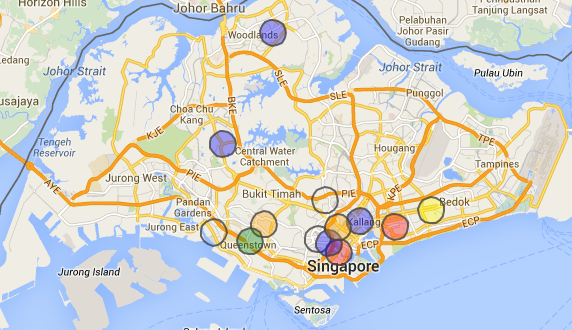
A map snapshot for the benefit of web-crawlers that can’t “see” Google Maps:

